【QGIS数据源】添加常用的数据源
已被阅读 3869 次 | 文章分类:gis随笔 | 2022-05-09 22:53
在QGIS制图过程常需要搭配不同的底图做配合效果;整理了几个常用的地图数据源
1 添加XYZ_Tile瓦片数据源
亲测效果如下:

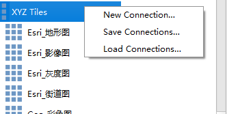
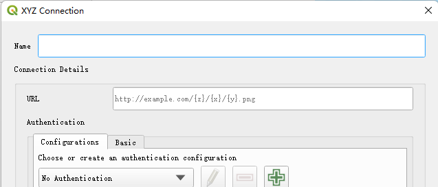
右键XYZ tile;然后键入对应的名称和url即可;


地址如下
Esri_地形图https://server.arcgisonline.com/ArcGIS/rest/services/World_Topo_Map/MapServer/tile/{z}/{y}/{x}
Esri_影像图https://server.arcgisonline.com/ArcGIS/rest/services/World_Imagery/MapServer/tile/{z}/{y}/{x}
Esri_灰度图https://server.arcgisonline.com/ArcGIS/rest/services/Canvas/World_Light_Gray_Base/MapServer/tile/{z}/{y}/{x}
Esri_街道图https://server.arcgisonline.com/ArcGIS/rest/services/World_Street_Map/MapServer/tile/{z}/{y}/{x}
Geo_彩色图https://map.geoq.cn/ArcGIS/rest/services/ChinaOnlineCommunity/MapServer/tile/{z}/{y}/{x}
Geo_灰度图http://map.geoq.cn/arcgis/rest/services/ChinaOnlineStreetGray/MapServer/tile/{z}/{y}/{x}
google_卫星图:https://khms0.google.com/kh/v=923?x={x}&y={y}&z={z}
Mapzen_地形图:https://s3.amazonaws.com/elevation-tiles-prod/terrarium/{z}/{x}/{y}.png
高德_卫星图:https://webst04.is.autonavi.com/appmaptile?style=6&x={x}&y={y}&z={z}
osm_地形图:https://tile.opentopomap.org/{z}/{x}/{y}.png
osm_街道图:https://tile.openstreetmap.org/{z}/{x}/{y}.png
Stamen_地形图:http://tile.stamen.com/terrain/{z}/{x}/{y}.png
stamen_墨粉图:http://tile.stamen.com/toner/{z}/{x}/{y}.png
stamen_水色图:http://tile.stamen.com/watercolor/{z}/{x}/{y}.jpg
2 添加WMS地图服务源
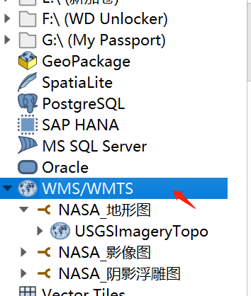
右键WMS/WMTS,点击新建连接

添加如下三种数据源:

地址如下
NASA_影像图:
https://basemap.nationalmap.gov/arcgis/rest/services/USGSImageryOnly/MapServer/WMTS/1.0.0/WMTSCapabilities.xml

NASA_阴影浮雕图
https://basemap.nationalmap.gov/arcgis/rest/services/USGSShadedReliefOnly/MapServer/WMTS/1.0.0/WMTSCapabilities.xml

NASA_地形图
https://basemap.nationalmap.gov/arcgis/rest/services/USGSTopo/MapServer/WMTS/1.0.0/WMTSCapabilities.xml
- 1 Qgis入门使用(打开数据源,转换数据格式,添加标注,符号化地图等)
- 2 【天地图403错误】key不正确或者设置白名单引起
- 3 cesium(一):认识CZML对象
- 4 openlayers实现流动箭头样式的路线
- 5 openlayers加载天地图在线地图(矢量,注记,影像图,地形图)并切换底图
- 6 【GIS效果:旋转】cesium 实现绕点旋转效果
- 7 【GIS效果:立体多边形】使用js绘制阴影多边形
- 8 leaflet入门教程(七):添加栅格图层imageOverlay、videoOverlay
- 9 【openalyers效果:地图范围裁剪】控制地图显示范围的三种方式
- 10 【GIS效果:淹没水体】cesium 淹没分析效果实现