ArcGIS API For JavaScript 调用WMS地图服务
已被阅读 2746 次 | 文章分类:ArcGIS API For Javascript | 2018-04-11 19:50
WMS通过Internet提供带有地理信息图片的服务标准,地图被定义为地理数据的可视化表现,WMS返回的地图并非地图数据,而是地图图像,格式类型可以是 PNG、GIF、JPEG、SVG、WebCGM 等;发布WMS地图服务和普通的Mapserver一样,只不过勾选了WMS功能.
一:发布WMS地图服务
发布WMS地图服务和普通地图服务类同,只需勾选WMS功能即可;其他步骤参考

二:查看WMS地图服务地址(ArcvGIS API调用的地址),判断是否发布成功
打开ArcMap,添加一个arcgis server,然后找到发布的地图服务;右键服务属性,如下图
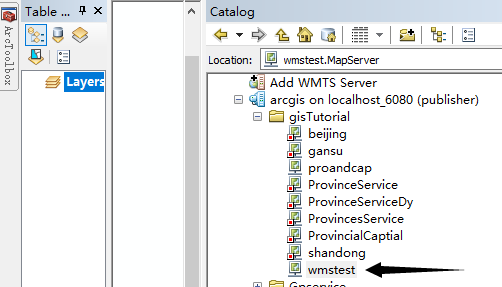
找到对应的服务地址,可以看到WMS地址为soap类型的地址,SOAP是一种数据交换协议规范,是一种轻量的、简单的、基于XML的协议的规范

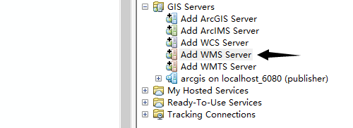
如何判断是否发不成功呢,接下来添加一个WMS server;右键WMS Server
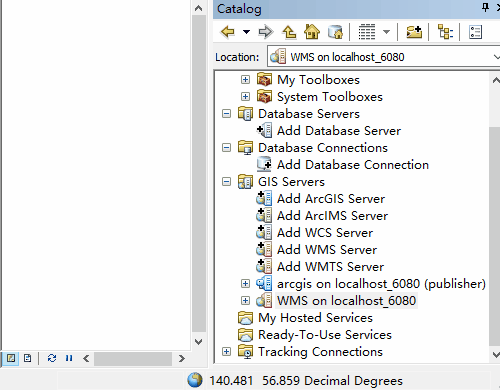
输入上一步查看的地址,然后点击getlayers,如果能显示地图图层,说明发布成功

拖曳图层到地图查看窗口,查看地图图层
三:调用WMS地图服务
<!DOCTYPE html>
<html>
<head>
  <meta http-equiv="Content-Type" content="text/html; charset=utf-8">
  <meta name="viewport" content="initial-scale=1, maximum-scale=1,user-scalable=no" />
  <title></title>
  <link rel="stylesheet" href="http://localhost:8008/3.18/esri/css/esri.css">
  <script src="http://localhost:8008/3.18/init.js"></script>
  <script type="text/javascript">
    var map;
    require([
      "esri/map",
      "esri/layers/WMSLayer",
      "esri/geometry/Point",
      "esri/geometry/Extent",
      "dojo/domReady!"],
        function (
          Map,
          WMSLayer,
          Point,
          Extent) {
          var map = new Map("map");
          var resourceInfo = {
            extent: new Extent(70.666864, 21.805866, 139.104808, 55.22917, { wkid: 4326 }),
            layerInfos: [],
            version: '1.3.0'
          };
          var agsWmsUrl = "http://localhost:6080/arcgis/services/gisTutorial/wmstest/MapServer/WMSServer";
          var agsWmsLayer = new WMSLayer(agsWmsUrl, { resourceInfo: resourceInfo });
          agsWmsLayer.setImageFormat("png");
          agsWmsLayer.setVisibleLayers(["0","1"]);//设置可见图层有哪些,数组元素为图层name值
          map.addLayer(agsWmsLayer);
        });
  </script>
</head>
<body>
    <div id="map">
    </div>
</body>
</html>
效果图:

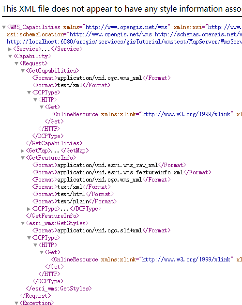
通过SERVICE=WMS和REQUEST=GetCapabilities 两个参数可以查看一个以xml文档形式返回的服务级元数据,完整请求地址http://localhost:6080/arcgis/services/gisTutorial/wmstest/MapServer/WMSServer?request=GetCapabilities&service=WMS
- 1 Qgis入门使用(打开数据源,转换数据格式,添加标注,符号化地图等)
- 2 【天地图403错误】key不正确或者设置白名单引起
- 3 cesium(一):认识CZML对象
- 4 openlayers加载天地图在线地图(矢量,注记,影像图,地形图)并切换底图
- 5 openlayers实现流动箭头样式的路线
- 6 【GIS效果:旋转】cesium 实现绕点旋转效果
- 7 【GIS效果:立体多边形】使用js绘制阴影多边形
- 8 leaflet入门教程(七):添加栅格图层imageOverlay、videoOverlay
- 9 【GIS实践:多维工具】ArcGIS打开nc数据
- 10 【openalyers效果:地图范围裁剪】控制地图显示范围的三种方式